Amazon Margin
The Story of Expedition 387
a História da Expedição 387 (em português abaixo)
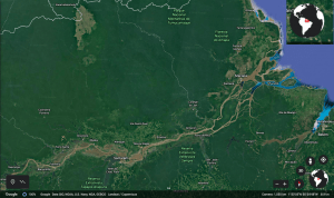
Google maps satellite view of the Amazon River main stem flowing into the Atlantic Ocean.
The Amazon as we know it today is the world’s largest river*, a network of land and water so massive that you can see it from space. It flushes through a watershed that encompasses the Andes Mountains and the largest rain forest on the planet, intersecting the boundaries of nine nations and providing a home for 30 million people. As it crosses South America eastward, it carries huge quantities of rock, soil and vegetation in river particles to the Atlantic Ocean. Satellite images over the central Brazilian Amazon reveal the unmistakably brown, sediment-rich waters of Amazon tributaries meandering through dense green forest.
Month to month, the image that you find above will shift, as the Amazon River rises and falls, following the rainy and dry seasons. Rising, it spills over the land and blurs together small channels of water. While falling, it re-exposes river banks and reestablishes separate waterways. It is perhaps more challenging to imagine how the Amazon rain forest and river changed over longer time intervals, thousands or even millions of years past. Fortunately, the story of the Amazon River Basin has been preserved as long as rivers have shuttled sediments from tropical South America into the Atlantic Ocean.
Here, we are thrilled to take you through the exciting journey of IODP Expedition 387, where scientists will look beneath the modern seafloor – to seafloors of the past – to stitch together a record of the Amazon River Basin’s history.
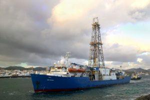
The JOIDES (Joint Oceanographic Institutions for Deep Earth Sampling) Resolution is capable of recovering columns of seafloor sediments without actually having to go to the bottom of the ocean. (source: IODP Cumulus)
Prior research on seafloor sediment deposits have revealed snapshots of the drainage basin’s dynamic existence all the way back to the Cretaceous Period, the Age of the Dinosaurs, more than 65 million years ago . Between then and now, the balance between speciation (evolution of new species) and extinction, grassland and woody forest landscapes, warm-dry and cool-wet climates, shifted constantly. Not even did one major river always flow across South America! Changes in the chemistry of more “recent” seafloor sediments – i.e., from prior to 2.5 million years ago – tell us that large mountainous arches between the Andes and the Atlantic impeded one major river from crossing South America as it does today.
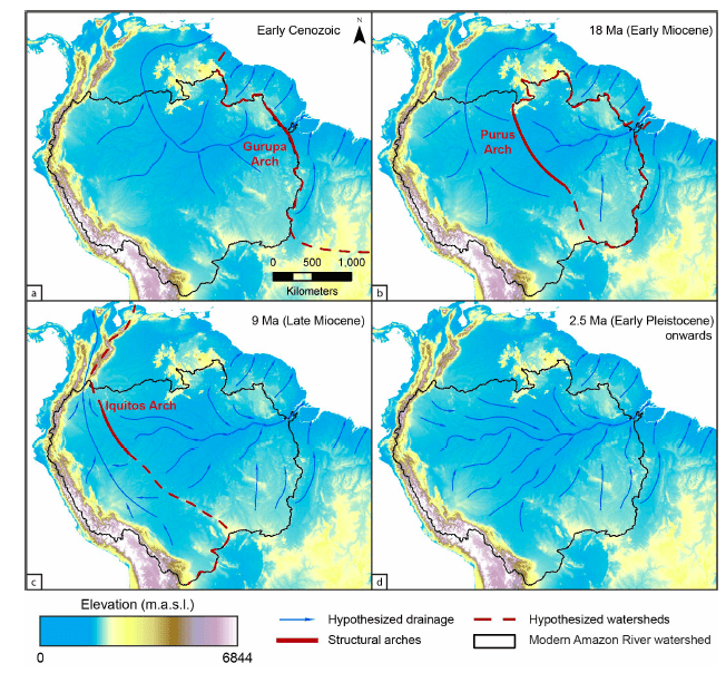
From the Expedition 387 Prospectus, this "comic strip" spans 60 million years, illustrating the development of the modern Amazon River Basin. As the hypothesis goes, before 2.5 million years ago, many arches (red lines) bisected the basin, such that only small rivers (blue arrows) flowed into the Atlantic Ocean. Between 9 and 2.5 million years, a massive river finally connected the Andes Mountains to the Atlantic Ocean, resembling the Amazon River we know today. The color bar represents elevation of the land surface in meters above sea level.
This upcoming spring, we will become residents of the JOIDES Resolution for 61 days, and travel to the Amazon Margin, the intersection of the Amazon River and the Atlantic Ocean. Uniquely equipped to core down to sediment deposits over 2000 meters below the sea floor, we will recover the longest continuous 55-million-year record of the Amazon River, rain forest and adjacent ocean history available to scientific inquiry.
Our expert team is diverse: palynologists to decipher plant species from fossilized pollen fragments, organic geochemists to interpret the origin of molecules transported from land to sea, coring engineers to keep us afloat even while tethered to sediments 2000 meters below the seafloor. Together, we seek to address some key questions:
- When exactly did the Amazon River first traverse the whole continent of South America, and how quickly did this happen?
- At what pace did the biodiversity of the rain forest grow and develop?
- How did shifts in the river’s positioning and Atlantic Ocean climate drive these biodiversity changes through time?
We hope that by better understanding the development of the Amazon River Basin over millions of years past, we can better appreciate its presence in our lifetimes, and advocate for its persistence into the future.
* By largest we mean the most flow of freshwater into the sea. The Amazon River actually competes with the Nile River for being the world’s longest river.
********************************************************************************************************************************************
Agora em português!
Uma imagem de satélite de Google Maps, mostrando o Rio Amazonas fluindo para o Oceano Atlântico.
O Rio Amazonas, como conhecemos hoje, é o maior rio do mundo*, uma área de terra e água tão grande que você pode vê-la desde o espaço sideral. O Rio flui através de uma bacia hidrográfica que inclui a Cordilheira dos Andes e a maior floresta tropical do planeta, cruzando as fronteiras de nove nações e apoiando 30 milhões de pessoas. Passando a América do Sul para o leste, transporta enormes quantidades de pedra, solo e vegetação em sedimentos para o Oceano Atlântico. Imagens de satélite sobre a Amazônia revelam o tributários, inconfundivelmente marrons, do Rio Amazonas serpenteando pela densa floresta verde.
Mês a mês, a imagem que você encontra acima mudará, enquanto o Rio Amazonas sobe e desce, acompanhando as estações chuvosa e seca. Elevando sobre a terra, o rio mistura pequenos canais de água. Baixando, restabelece hidrovias separadas de novo.Tal vez, seja mais dificil imaginar como a floresta amazônica e o rio mudaram através intervalos de tempo mais longos, milhares ou milhões de anos atrás. Afortunadamente, a história da bacia do Rio Amazonas foi preservada enquanto o Rio Amazonas transportou sedimentos da América do Sul tropical para o Oceano Atlântico.
Aqui, estamos emocionados levar você através a viagem de Expedição IODP 387, onde cientistas examinão debaixo do fundo do mar moderno buscando um arquivo da história da bacia do rio Amazonas.
O barco JOIDES Resolutioné capaz de recuperar colunas de sedimentos do fundo do mar sem realmente precisar ir para o fundo do oceano (Foto de IODP Cumulus).
Pesquisas anteriores sobre sedimentos antigos no fundo do mar revelaram instantâneos da história dinâmica da bacia hidrográfica desde o período Cretáceo, a era dos dinossauros (mais de 65 milhões anos atrás. Entre esse período e agora, o equilíbrio entre especiação (evolução de novas espécies) e extinção, entre floresta e cerrado, entre climas quentes-secos e climas frios-úmidos mudavam constantemente. Ademais, alterações na química de sedimentos mais recentes do fundo do mar – anteriores a 2,5 milhões de anos atrás – revelam que grandes arcos montanhosos entre os Andes e o Oceano Atlântico impediram que um grande rio cruzasse a América do Sul, como cruza hoje.
Da proposta para Expedição 387, esta "história em quadrinhos" se estende por 60 milhões de anos, ilustrando o desenvolvimento da moderna Bacia do Rio Amazonas. Segundo a hipótese, antes de 2,5 milhões de anos atrás, muitos arcos de montanhas (linhas vermelhas) cortavam a bacia hidrográfica, de modo que apenas pequenos rios (setas azuis) fluíam para o Oceano Atlântico. Entre 9 e 2,5 milhões de anos, um rio grande finalmente conectou os Andes Montanhas e o Oceano Atlântico, como o Rio Amazonas que conhecemos hoje. Nota que os cores representam a elevação da superfície da terra (metros acima do nível do mar).
Este abril que vem, seremos residentes da JOIDES Resolution por 61 dias e viajaremos para a Margem Amazônica, a interseção entre o Rio Amazonas e o Oceano Atlântico. Equipado unicamente com instrumentos para coletar sedimentos a mais de 2000 metros abaixo do fundo do mar, recuperaremos o arquivo histórico mais longo e contínuo, estendendo 55 milhões de anos, do Rio Amazonas, Floresta Amazônica e oceano adjacente.
Nossa equipe de especialistas é diversa: palinologistas para decifrar os espécies vegetais de fragmentos de pólen fossilizados, geoquímicos orgânicos para interpretar a origem de moléculas transportadas da terra para o mar, engenheiros para manter-nos acima do mar quando conectados a sedimentos 2000 metros abaixo do fundo do mar. Juntos, tentamos de explorar estas preguntas críticas:
- Exatamente quando o Rio Amazonas atravessou pela primeira vez todo o continente da América do Sul, e com que rapidez?
- Com que rapidez creceu a biodiversidade da Floresta Amazônica?
- Como as mudanças no posicionamento do rio e no clima influenciaram essas mudanças na biodiversidade?
Esperamos que em entender melhor o desenvolvimento da Bacia do Rio Amazonas nos últimos milhões de anos, possamos apreciar melhor a presença dela em nossas vidas, e apoiar a persistência da Amazônia no futuro.
* Queremos dizer que o Rio Amazonas tem o maior fluxo de água doce no mar do mundo. O Rio Amazonas, na verdade, compete com o Rio Nilo por ser o rio mais longo do mundo.