Tracking Tsunamigenic Slip Across the Japan Trench (JTRACK)
 On March 11, 2011, a devastating 9.0M earthquake was generated off the east coast of Japan, resulting in tsunami waves up to 40 meters high. It has been estimated that over 19,000 people died during this disaster. The source of this unparalleled event was the Japan Trench, a subduction zone to the east of the island of Japan.
Subduction zones are known to be the source of Earth’s largest earthquakes, due to the great stresses that develop as the subducting plate is pulled beneath the overriding plate. When a significant area of the seafloor is displaced during a massive earthquake, this disruption to the water column can generate a tsunami, resulting in even greater devastation as the coastline is inundated.
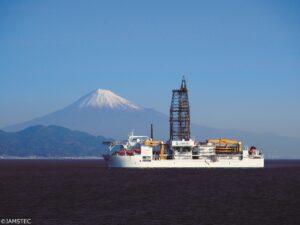
On September 6, 2024, Expedition 405: Tracking Tsunamigenic Slip Across the Japan Trench (JTRACK) began aboard the drilling vessel Chikyū. The primary objective of this expedition is to investigate the shallow slip across the Japan Trench that led to the unprecedented 2011 Tohoku-oki earthquake.
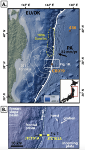
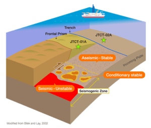 Over the course of this four month expedition, the Chikyū will visit two sites. The first, JTCT-01A, is the previously drilled site C0019 from Expedition 343: Japan Trench Fast Drilling Project (JFAST), located on the frontal prism, east of the trench. This site will access the fault zone in the region that generated the large, shallow slip observed during the earthquake. The second site, JTCT-02A, is located on undisturbed sedimentary rocks of the overriding Pacific Plate, forming a transect across the trench. At both sites, a Logging-While-Drilling hole will be bored, allowing scientists to collect logging measurements. During the next phase of the drilling, coring tools will provide scientists the opportunity to recover cores from the seafloor down to the basalt of the subducting plate boundary. Additionally, a sub-seafloor observatory will be installed at Site JTCT-01A, in order to measure high-resolution temperature over time at multiple depths within the fault zone.
By carrying out this operational plan, the scientists of JTRACK intend to deepen our understanding of subduction zones in three significant ways:
- Characterize the geologic composition and structure of the frontal prism, décollement, and subducted oceanic crust to determine how these materials and structures control earthquake mechanics or reveal evidence of past earthquakes and deformation.
- Characterize the stress state within and around the fault zone that experienced large slip during the 2011 Tohoku-oki earthquake.
- Characterize the hydrogeology of the plate boundary fault zone and frontal prism.
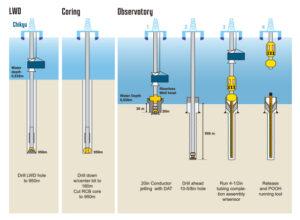
To learn more about the expedition, meet the science party, and stay up-to-date with the expedition blog, visit the Expedition 405 website.
JTRACK is the last scheduled expedition under the current phase of the International Ocean Discovery Program, and thus marks the end of a prolific decade of globally collaborated ocean research. Scientific ocean drilling aboard the Chikyū will continue under the auspices of the International Ocean Drilling Programme (IODP3), jointly run by ECORD and JAMSTEC, starting on January 1, 2025.
