The Decline and Fall of a Volcanic Island
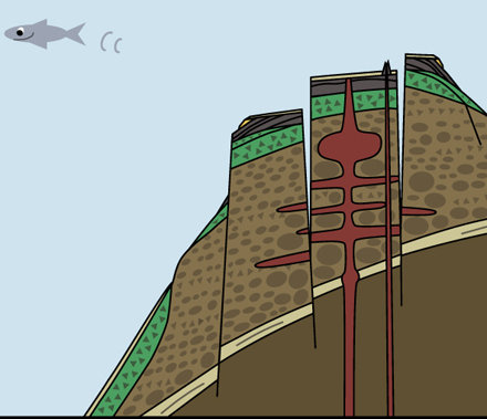
Someday, seventy million years from now when the cockroach people are the dominant species on the planet, they are going to have their own marine research drilling program and are going to be drilling on a seamount whose top is 1,500 meters below the surface, and are going to be surprised when they discover a sedimentary core that has a Don Ho record in it, because it turns out the seamount is the Big Island of Hawaii.
With the possible exception of the cockroach people (and also, I guess, the Don Ho record surviving that long in sedimentary rock), this is not as fantastic as it sounds. Just as volcanic islands have a common pattern of growth (see my last blog), they also have a common pattern of decline. It is pattern you can actually see in this NASA photo of the Hawaiian islands:
.jpg)
The Big Island at the far right lives up to its name, because the farther left (west) you look, the smaller the islands become (they are so small that I had to endanger my eyeballs by staring very closely at the computer screen in order to find them all and put in the arrows pointing at them). The islands are not only smaller the farther west you look, they are also older. They look smaller partially because they are losing mass to the unstoppable eroding power of the ocean, but mainly because all of these islands are sinking.
A volcano can come into existence pretty quickly (in geologic terms, it is almost instantaneous) and a volcanic seamount can turn into an island in a human lifetime (in fact, if you are more than two years old, it has happened in your lifetime, near Tonga. To see video and read about this, check out this National Geographic webpage. It also happened when Surtsey Island came into existence in the 1960’s near Iceland, which you see in the NOAA photo below).

When these volcanic islands are no longer receiving a supply of fresh magma and therefore no longer growing, they have added a lot of mass to the ocean plate they are sitting on, and the plate will begin to buckle under the weight causing the seamount to sink. The seamount then continues to sink because the ocean plate is sinking anyways as the plate moves towards the subduction zone (see my previous blog). The ocean plate does this because it is aging, and like many of us who are aging, it is putting on some pounds. It gains weight, not because a slowing metabolism makes it more risky to eat donuts, but because the magma directly underneath it continually solidifies into rock on it adding to the plate’s mass. The trenches at the subduction zones then pull the plate down even further. So the seamounts we are drilling on now that are right by the Kermadec-Tonga Trench, and which were probably like Surtsey Island about 70 million years ago, are now over 1,500 meters below the sea surface.
The final fate of seamounts is down in the subduction zone (again, see my previous blog), except, of course, when it isn’t. Some seamounts go into the subduction zone, but then end up being scraped onto the continental plate to become part of the land (the Blue and Klamath Mountains of Oregon are examples of this). Also, the Atlantic Ocean seafloor seamounts for the most part are not heading into any subduction zones, at least at this point in Earth’s history, but that is another blog post that I may not have time to write (since it’s not as directly related to what we are doing on this expedition as some other topics).