Live science: first results of ocean drilling 362 expedition
 When earthquakes happen in the ocean, they can displace huge volumes of water and cause tsunamis. This was the case in 2004 when a magnitude >9 earthquake struck North Sumatra and the Andaman-Nicobar Islands leading to a huge tsunami with coastal waves reaching 15 meters or more. Although earthquakes are expected in subduction zones, the 2004 earthquake ruptured to much shallower depths and closer to trench than most other subduction earthquakes and ended beneath the accretionary prism. This earthquake, as well as several others in the past 15 years (especially the Japan Tohoku-Oki earthquake in 2011), surprises earth scientists in terms of their size and the amount and location of the fault slip.
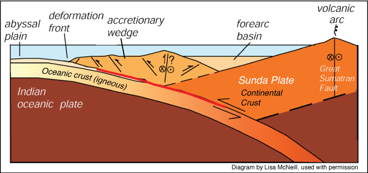
See the geological setting of the Sumatra subduction zone:

The North Sumatra margin is distinctive from other accretionary prism because of the thickness of the sediments stacked on the sea-floor of the Indian plate – 1,5 km thick increasing to 5 km at the deformation front. A significant part of the sediments come from the Himalayan mountains, triggered by sediment gravity flows, nearly 2000 km away from our drilling sites! Scientists think that these very thick sediments may explain the unusual type of earthquake of 2004. One goal of Expedition 362 was “to find out more about how specific sediments control the size and type of earthquakes in this kind of environnement” explained Lisa McNeill of the University of Southampton.
During August and September 2016, we spent two months drilling the boreholes U1480 (1432 m depth) and U1481 (1500 m depth) on a section of the seafloor ~200 km west of Sumatra in order to sample the thick sedimentary sequence before it reaches the subduction zone. The sediments were deposited on the seafloor over the last ~70 million years, but the majority were deposited in the ~ last 9 million years.
Current models of subduction predict that rupture should occur at depth within the subduction zone. The mechanical and hydrogeological conditions (i.e. fluid generation) of the fault interface control when and where megathrust (subduction plate boundary) earthquakes occur. And these conditions are closely linked to the properties of the materials being sudducted. Fluids released by compaction of the sediments and by mineral dehydration reactions as the temperatures of the sediments increase as they are buried have a major role in how the fault behaves. Yet, the 2004 Sumatra-Adaman and the 2011 Tohoku-Oki earthquakes do not fit these models because the slip extented much more farther and closer to the seaward limits of the subduction forearc than predicted.
Studies of samples from the boreholes helped the 362 scientists to reappraise the current models of subduction whic failed, until now, to explain the unusual earthquakes.
And the first results just got published in one of the famous science journals! Have a look here!
What does this article explain? How does it improve our comprehension of subduction zones around the world?
Firts, you have to understand that earthquakes are closely linked to the capability of the rock to break under stress which means that it has to be hard enough. Sediment deposits turn into rocks during a phase called diagenesis. This occurs due to burial beneath more sediments which leads to increased temperature and pressure: sediments lose bounded water under pressure and chemical reactions occur and change their physical properties. Part of the diagenesis process is dehydration of the minerals – this produces fresh water which is released but also changes the composition and properties of the changed minerals. These reactions are very important for the behavior of the sediments because they ultimately increase their strength and their ability to cause an earthquake.
The seismic line shows a particular seismic horizon (labeled in the figure below “high amplitude negative polarity reflector”) which was thought to be a weak, fluid-rich layer before the subduction zone. This horizon could be the locus for the plate boundary fault initiation which means that earthquakes would occur along this horizon but we didn’t know its properties or the cause of the fluid.

Our geochemist team spent 2 months squeezing the sediments of hole U1480 and U1481 in order to analyze composition of the water from the sediments pores. Production of freshwater is a sign of dehydration reactions. Geochemical analyses have confirmed that fresh water is present and that diagenesis is happening. As these sediments get closer to the subduction zone and more fresh water is generated, the seismic horizon properties indicate it is an important reservoir of water released from dehydrating minerals. Slides of the sediments onboard showed that part of the source of the water was originally volcanic glass from volcanic eruptions.
Dehydration simulations were used to estimate fluid production as temperature increased (as sediment load and burial increased) toward the subduction deformation front. Model results demonstrate that fluid produced by dehydration reactions exceeds fluids produced by compaction of sediments. Sampling of the incoming material at the North Sumatran subduction zone provides direct evidence that the diagenesis reactions that release water and make the sediments and rocks stronger and more likely to rupture as an earthquake have happened before subduction. This is consistent with the shallow slip which was observed during the 2004 earthquake.
Scientists of expedition 362 have shown that there is a varied set of conditions that control earthquake slip and that if we want to better understand how earthquakes happen, we have to take into account the nature of sediments in subduction models, particulary in places were very thick sediments have built up.
I am very proud to have been a tiny part of this great expedition. Congrats to the 362 scientists!