Bergy Bits and Growlers: Ice Navigation in the Arctic

In this blog, we speak with Victor Gronmyr, an Expedition 400 ice navigator, about the tools he uses to keep icebergs at bay and the JOIDES Resolution safe.
How did you become an ice navigator?
I am a retired Canadian Coast Guard Captain, with 33 years of Coast Guard service. I was fortunate enough to spend many seasons in the Canadian Arctic understudying experienced Coast Guard captains. Eventually, I got to be a captain of an icebreaker myself. I’m in my 17th season working in polar waters and am an ice navigator with Martech Polar Consulting. https://martechpolar.com I confer regularly with the principal consultant, Captain Duke Snider, my mentor of over 30 years, as well as dozens of colleagues via the company’s WhatsApp Channel.
What do Ice Navigators do?
One of our primary functions is to help the captain, ship’s officers and crew avoid dangerous hard ice.
Simply put – We don’t dent ships!
While navigating in the polar waters of Greenland we need to be aware of both sea ice and glacial ice. Expedition 400’s nearshore location for this time of the year in Baffin Bay means that glacial ice is the biggest concern. From the moment the Greenland glaciers calve into icebergs, they disintegrate until they completely melt. This breaking apart is also referred to as calving, or what I call “sharding,” and produces smaller icebergs, “bergy bits” and “growlers.”
What makes bergy bits and growlers unique?
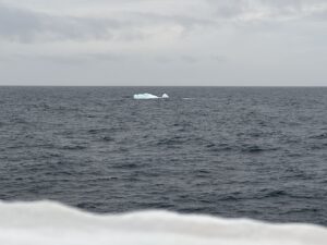
Glacial ice is incredibly hard – it is like reinforced concrete. Bergy bits are glacial ice with heights of 1 to 5 meters above the sea surface. Growlers have heights of 0 to 1 meter above the water’s surface and 4 to 9 meters below. Both can, and will sink ships. Their low height in the water makes growlers very hard to sight. The only sure-fire method is visually, by eye.
What other types of tools do you use as an ice navigator?
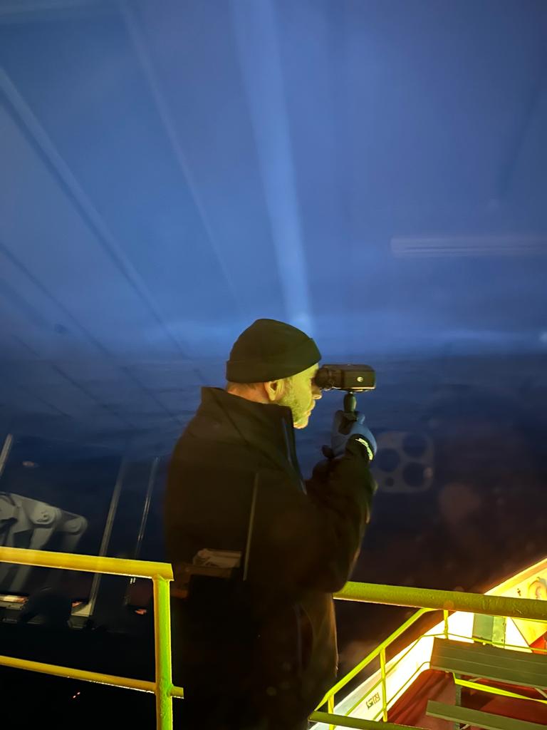
Ice charts, satellite imagery, marine radar and ice radar, and our own eyes. There are many visual aids that I use: Polarized sunglasses, binoculars, searchlights and FLIR.
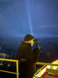
Can you tell us more about FLIR?
FLIR stands for “Forward Looking Infrared.” They are essentially binoculars with a temperature sensor. They are easy to use and are very reliable.
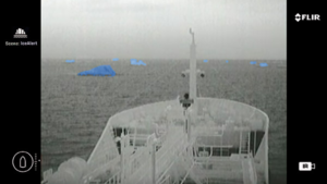
How does FLIR work?
FLIR is a thermal device that picks up on infrared waves emitted by an object. The primary source of infrared radiation is heat or thermal radiation. The warmer the object, the more infrared radiation it emits.
Infrared is completely invisible to the unaided human eye. With FLIR you can adjust the visual settings. My favorite presentation is to have black as hot and white as cold. The super cold iceberg whose core temperature is about -15 degrees Celsius shows really well as bright white against the relatively warm salt water, which at 2 degrees Celsius shows as gray-to-black.
Is FLIR different from night vision?
They operate in different ways. Night vision devices amplify existing light so they need light to work, but not too much. They work best in the dark or in low light by enhancing the traces of visible light. On the other hand, thermal imaging as done by FLIR requires no light to work. FLIR works in complete darkness, full daylight or rapidly changing light levels.
For over a decade, oil tankers traveling in Greenlandic polar waters have been experimenting with FLIR. FLIR is allowing the ships to detect ice day or night from a distance so collisions can be avoided.
Are there any drawbacks to FLIR?
FLIR cannot see past glass, so during Expedition 400, ice navigators must leave the warmth and comfort of the Bridge and go outside with the FLIR binoculars to make observations. Here’s a case where night vision is more flexible. It can see past glass as it is enhancing the visible light.
I have to ask, what was the size of the iceberg that sunk the Titanic?
Estimates of the iceberg would put it into the medium category, the peak rising approximately 30 meters above the surface of the ocean and a length of about 120 meters. A 1976 United States Coast Guard Study on icebergs in Iceberg Alley of Davis Strait (between mid-western Greenland and Baffin Island) found that icebergs have a height to draft ratio of approximately 1 to 3.95. The draft is the depth below the water line. With this methodology, the Titanic’s iceberg was roughly 120 meters deep below the surface of the water. The same study provided a way to estimate the iceberg’s mass which would suggest that the Titanic’s iceberg would have contained approximately 1.3 million metric tons of ice, or about 2.8 billion pounds.
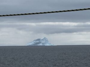
Expedition 400 has also kept company with some big icebergs!
Yes, we’ve moved away from some a few times. For about two weeks, we were in the vicinity of what is classified as a “Very Large Iceberg.” We affectionately called it “Fred.” As we retrieved cores, Fred veered as close as 3.5 nautical miles, then out to about 20 nautical miles. This happened a few times before we moved on to the next site. Fred was pointy on top, classified as “pinnacle shaped,” and was about 140 meters above the surface of the water by about 310 meters in length. Fred’s mass would be in the neighborhood of 40 million metric tons.
Icebergs may be enigmatic and formidable, but with skilled ice navigators assisting the captain and his team, Expedition 400 continues to uncover the secrets of the world’s polar regions while staying safe.