In transit to Antarctica
(Blog posted for Sandra Passchier. Originally posted at http://msuinantarctica.blogspot.com/)
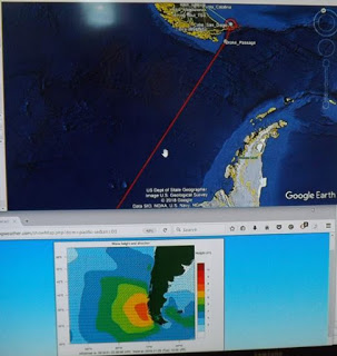
We left yesterday, on January 23, and took the route from Punta Arenas through the Magellan Straights into the Atlantic Ocean, because low pressure systems with high wave heights were present to the West. On the map is our ship’s location near the tip of South America and the Antarctic Peninsula projecting North. The map at the bottom is the wave height projection. This information is available on monitors around the ship. At present we are passing between Isla de Los Estados and the Argentina mainland. The ship crew is enjoying the last views of land before we enter the Southern Ocean. The red line is the track we might follow through the South Pacific, although we will probably deviate from it to stay away from strong storm systems. We will probably arrive on our first site in Antarctica around February 1, weather permitting of course…