
Mediterranean-Atlantic Gateway Exchange
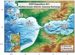
The first ever Land-2-Sea drilling project is set to sail this winter, as the JOIDES Resolution makes its way to the Mediterranean-Atlantic gateways. This expedition is part of the larger Investigating Miocene Mediterranean-Atlantic Exchange (IMMAGE) Project—a collaboration between the International Ocean Discovery Program (IODP) and the International Continental Scientific Drilling Program (ICDP). The project will drill at three offshore sites in the Atlantic and Mediterranean, and in future years, at two onshore sites that target fossil gateways that have been tectonically uplifted and preserved on land. Expedition 401 scientists will embark on this revolutionary journey to study the gateway and the secrets it holds from millions of years ago.
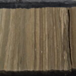
Today, the exchange of seawater between the Mediterranean and Atlantic ones through the Gibraltar Strait. Around 8 million years ago, however, there were two other gateways, one in northern Morocco and one in southern Spain. As millions of years went by the connections grew narrower and narrower until they closed, blocking exchange. This event caused the Mediterranean sea level to fall by hundreds of meters and the water to become so salty that a layer of salt crystals more than 1500 meters thick formed across its seafloor. This phenomenon is called a “salt giant”. Around 5.5 million years ago a cataclysmic flood reconnected the Atlantic with the Mediterranean sea, terminating salt giant formation and transforming the Mediterranean into what we see today.
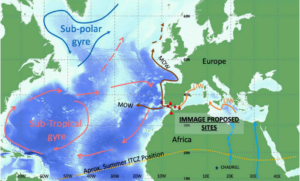
These extraordinary events changed not only the chemistry of the global ocean but also its circulation patterns, impacting global climate. It may have contributed to a major episode of planetary cooling that ultimately led to permanent ice formation in the Arctic. Led by co-chief scientists Rachel Flecker and Emmanuelle Ducassou, Expedition 401 scientists seek to understand and quantify the climatic changes driven by restricted water exchange and salt giant formation through analysis of the chemical and physical properties of the sediments preserved in and on either side of the Atlantic-Mediterranean gateway.
Some of the specific scientific objectives include:
- Identifying when the Atlantic first began to receive water flowing out of the Mediterranean with distinctly different physical and chemical properties.
- Understanding the cause of the Mediterranean salt giant and its local, regional and global climatic consequences.
- Testing hypotheses around how water with extremely contrasting densities mix in the ocean and improving the numerical representation of this process in ocean circulation models.
The first ever land-to-sea drilling project allows these scientists to explore and compare secrets of the Earth we have never been able to discover before. Follow the scientists on Expedition 401 as we uncover the climate changes of our past.
Learn more about EXP401 and it’s science party here.